Monthly Archives: November 2009

Ericsson Labs OSM library

Ericsson labs have released an OSM library:

A couple of months ago we released support for OpenStreetMap maps for our Web Maps API and the Java ME version of the Mobile Maps API. We are now happy to release it for the Android version of our Mobile Maps API. Mobile Maps for Android with OpenStreetMap allows any developer to integrate the maps from the OpenStreetMap project into any Android application and have them rendered in the fast and dynamic Mobile Maps engine.

Scientific American on OSM

Check out this article over at SciAM:

It seems there’s an online community or social network for every facet of life these days. One area where this makes a lot of sense is in map-making, given how well locals know their own territory. This might explain why OpenStreetMap—a map of the world that can be edited by anyone with Web access—has expanded from 100,000 contributors in June to more than 180,000 (and claims to be adding 300 new mappers daily).

State of the Map 2010

I wanted to keep the community up to date on happenings with the SOTM committee meetings. Everyone, yes, everyone is welcome to join! Today we had a great meeting with fellow OSMers Ivan Sanchez Ortega, Will King of Geodata Solutions, Emilie Laffray, Richard Weiat just to name a few.

SOTM 2010

We talked about the current bids for 2010: both Spain and Italy are really excited to host the conference! It’s really awesome to see their enthusiasm.

As a committee we’re creating some criteria for the proposed host city. It’s not meant to limit the choices, but more help decide the best location. This makes everything very transparent and also lets unsuccessful bids figure out how to do better next time. It also lets SOTM organizers (and the OSM-F Board, if they want) to vote on the bids.

Some criteria could be:

* Easy access by public transport (plane, train, bus) with a maximum of 1.5 hour travel from major airport

* Availability of accommodation close to the venue

* Venue facilities (conference rooms, AV, WiFI, break out areas, right size)

* Venue catering

* Interestingness of the city

* How well the organizing committee will cope with the organization

* Outreach & marketing activities planned by the organizers

* Does the venue make SOTM accessible to a new group of OSMers (as opposed to the same people as last time)

With this in mind, the SOTM committee is extending the bid deadline another two weeks to December 1, 2009 and we will have a decision (drumroll please!) On December 7th.

We’re asking everyone to reach out in your circle of OSM friends to create new proposals. Twitter, FaceBook and the talk lists are just a few examples.

For information on how to write your proposal visit the the OSM wiki site here.

The Cake Test

During the course of history, we have used several types of tests to tell if something is what it seems to be, or to check if it is up to expectations.

Now we use industrial stress tests, quality assurance checklists and software metrics. We put dummies inside of cars and crash them into concrete walls at full speed, to check if the dummy gets out in one piece or not; then we decide whether the car is safe enough. Centuries ago, the church used the trial by water ordeal: tie a rock to a woman’s leg and throw her into a lake; if she drowns, she’s not a witch; if she comes back to the surface, she is a witch and has to die by burning.

Free software also has tests, which are scientifically more accurate than the trial by water, as one has to tell apart free-as-in-free-beer licenses from free-as-in-free-speech ones. During the development of free software licenses (such as the GPL) in the 90s, there are some tests which are well-known amongst free software advocates: the “desert island test”, the “dissident test” and the “tentacles of evil test”. These test were an integral part of the Debian Free Software Guidelines (or DFSG for short). The DFSG are just a definition, and are not easy to explain to a layman: it’s better to check against some use cases.

For example, the “desert island test” assumes a castaway in a desert island with a solar-powered laptop, and some software in it. For this software to be free, the castaway has to not be legally forced to distribute any changes made to that software, as he just can’t. Technically, this test checks that the license asks for source code redistribution only when the binaries are distributed. This tests makes it easier to understand whether a license complies with the DFSG, rather than checking against the DFSG themselves.

And what about geographical information? Is there any test that lets us know whether or not the information from National Mapping Agencies (NMAs) or Spatial Data Infrastructures (SDIs) is really available under conditions that allow the citizenship to make the most out of them?

In order to know if a given set of geographical information can be considered free (as in free speech) or open or “libre”, it can be checked against the Open Knowledge Definition (OKF), just as free software can be checked against the DFSG. However, the OKF can be a bit dense for laymen.

There is no easy test to know if a set of geodata is free/open/libre or not.

Until now.

I hereby propose the Cake Test.

SotM09 cakes

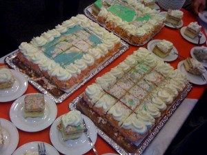
What is the Cake Test? Easy: A set of geodata, or a map, is libre only if somebody can give you a cake with that map on top, as a present.

The Cake Test

Cakes are empirical proof that most the data in most SDIs cannot be used freely, because of the licensing terms of the SDIs. And they are an empirical proof that attendants to the latest spanish SDI conference could taste themselves.

Even if maps, or geodata, are published in a web site for free (at no cost), it doesn’t mean that a cake can be made with them. Some examples of technical or legal obstacles for the “cakefication” of geodata are:

  • Not being able to download the geodata to a computer.
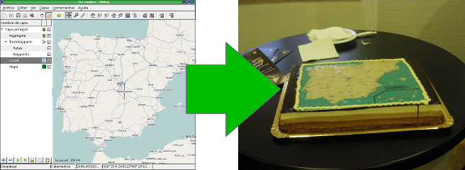
  • Not being able to copy the geodata to a different medium, or not being able to redistribute it. In order to make the cake, a bakery needs a CD with the images, or an e-mail with them.
  • Not being able to use the maps for profit (AKA “commercial use”), even if the person giving the cake away is not making any profit (AKA “indirect commercial use”). The one giving the cake does not make money, but the bakery does.
  • The obligation to sign a license (or such) for commercial use. Do you really expect people to go to a bakery and say “hey, I’d like a cake, but you need to sign this commercial-use-of-geodata-license thing first”?
  • The obligation to notify any usage of the geodata prior to using it. If we have to tell we’re making a cake, it wouldn’t be a surprise, would it?

A set of geodata must comply with lots of conditions in order to bake a cake with it, and may seem complex when applied to a geodata license (and the Cake Test is just a neccesary condition, not a sufficient one), but the goal of the Cake Test is very simple:

If a layman can’t decide whether he can or can’t decive if he is able to give away a cake as a present, or plainly isn’t able to, then the geodata cannot be used freely, is not free, and is not libre.

On the other hand, if some day someone gives a NMA or SDI a cake as a present, then that NMA or SDI is on the right track for information reuse. And the day that happens, they’ll probably throw a party, as they’d already have the cake.


The Cake Test also illustrates the concept of long tail.

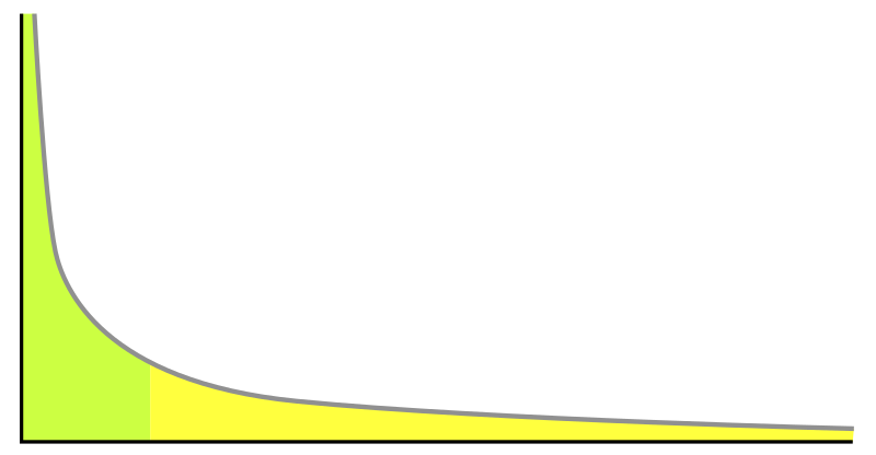
Usually SDIs and geoportals are built in order to the big geodata consumers to generate more profit, or lower their costs. This is the green section of the graph: quite few data consumers, but consuming a lot of data involving a lot of money. They are government agencies, and big corporations and projects. On the other end of the graph, in the yellow section, would be them cakes.

Obviously, cartography applied on top of pastry products is just a marginal contribution to a country’s Gross Income. But it’s not a null contribution and, most probably, no one thought about it before.

The long tail is full of cakes and other marvellous things that haven’t been invented yet. How many new uses for geodata are there to be discovered? How long is cartography’s long tail? The only certain thing is that, in order to know that, free use of geodata has to be encouraged.

(This is a translation of an article originally in Spanish, available here)

OSMF Logo Competition

The OSMF recently launched a new mediawiki powered site at http://www.osmfoundation.org/ with a basic logo.

We’d love to have a logo that better reflects the foundation, and would like to follow the success of crowd sourcing a logo for the SOTM conference.

If you have an idea for a logo please submit it here:

http://wiki.openstreetmap.org/wiki/Foundation/Logo

and the board will choose or request changes to a winning entry at the December board meeting. Please spread the word, we’d love to see all the different ideas possible.

Open Data from Toronto

Mark Kuznicki hosted the Toronto Open Data Lab at the Toronto Innovations Showcase this week.  This was the official launch of dataTO.org, Toronto.ca/open and the release of several open data sets.

I was pleased to meet so many folks working at the city of Toronto and at the province of Ontario who showed so much interest in Open Data.  There were many great conversations going on, from the exhibition floor at the city hall rotunda to the mixer at a local pub later.  All of these are great signs of a new open-awareness at the city and I see it as overwhelmingly positive.

Being new to the world of Open, the city wanted some feedback regarding for what applications people would use this newly available data.  As Toronto Transit Commission data, addressing data and road centrelines were all released I thought immediately of the travel planner for London from mySociety.

I had that chance to talk to many folks about OpenStreetMap through the course of the day and I was pleased to share my enthusiasm for a travel planner like this using the Toronto data.

Travel planner using Toronto Open Data

The data we have now is imperfect but rather than critiquing the quality of the dance steps of this bear, let’s marvel that Toronto released open data at all.  Most of the data sets grew up in separate silos in Toronto departments.  The folks at the city are as new to these data sets from other departments as we are.  They’ll get used to working with each other in an open environment and that will move them to more of the open tools, standards and practices that we take for granted.  I’m sure we’ll see a bug tracker soon.  We’ll see increased use of open formats rather than proprietary lowest-common-denominators.

Bravo, Mayor Miller, for recognizing the benefits of Open.  Bravo, Mark Surman for challenging Toronto to become a city that thinks like the web,  This is an important step along that way.

Toronto City Hall Photo is licensed cc-by-nc-sa by Vlastula on Flickr

London Travel time map is licensed cc-by-sa by Tom Carden.

Summary of LUG Radio Live ’09

There’s a good summary of LUG Radio Live 2009 over here including OSM happenings with a talk by Andy Robinson:

Andy Robinson, also known as “Blackadder”, is an active contributor to the OpenStreetMap (OSM) Project and is the current secretary of the OSM Foundation. OpenStreetMap is an open source project run by the OpenStreetMap Foundation, that is building free online maps, not based on any copyright or licensed map data. The OpenStreetMap maps are released under the Creative Commons Attribution Share Alike 2.0 license.