 We’ve just gone live with some changes to the map controls on the OpenStreetMap.org front page.
“Re-organise the map tools. Take them from all four corners and just put them together in a more organised way”, explained Designer Saman Bemel-Benrud in his SOTM U.S. presentation as he put forward this and many other ideas for front page design improvements.
As well as re-arranging things, you can now use browser geo-location to locate the map where you are (![]() ), and the map layers picker (
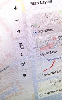
), and the map layers picker (![]() ) now gives a preview of the different map styles on offer (Those which we feature on the front page. There are many others of course)
) now gives a preview of the different map styles on offer (Those which we feature on the front page. There are many others of course)
We’re excited to unveil these changes which we think will improve the experience, particularly for new site visitors, and we will continue to make improvements in the coming months. Obviously if you’ve been using the OpenStreetMap website for some time, the re-arrangement may take some getting used to, but we hope you like it too!
Big thanks to John Firebaugh, Saman Bemel-Benrud, Tom MacWright who did the javascript development and design work for this with a healthy dose of feedback and collaboration from others. Many issues have already been discussed and weighed up, but if you have further feedback, the dev talk mailing list could be the best place for it. (Updated: discussion seems to be happening on the ‘talk’ mailing list)
I like it! It’s tidier having them all in the top right, and the third icon to locate yourself is a nice new addition.
Good work all! It looks nice.
I noticed what I think is a bug that snuck in: https://github.com/openstreetmap/openstreetmap-website/issues/353
big bug :
i live in bordeaux, fr
openstreemap locates me in dijon !
i use firefox 22
It’s not Openstreetmap which locates you, but your browser which uses different mechanisms to determine your current location and then hands over these coordinates to OSM to center the map.
ok it’s a pb with firefox
no pb of geo-location with chromium
Wow, what a welcome change! Looks great and intuitive.
I also like that the “add a note feature” is now much more prominent. Previously it was very well hidden in the bottom left corner…
Great job!
It looks nicer, but I’m very saddened by the loss of the zoom bar.
Agreed on this.
Never used it 🙂 I prefer +&- keys on keyboard
It is not only the navigation, it also gives you an idea of scale
Agreed, I instantly missed being able to tell the zoom level too; now I keep gueessing and zooming back and forth.
the added feature(s) are nice, but the usability has become worse… more clicks for the same things etc.
there is still no way to place a marker in the gui (the most requested feature i get from relatives and friends about osm), and the side bar on the left is still there and there is no way to get rid of it. i would prefer usability and features much over eye candy like the mini maps for the layer selection.
You might be interested in https://github.com/openstreetmap/openstreetmap-website/issues/331 re the side bar.
The site does actually react in a responsive manner to get rid of it if you half the width (ie: make it think it’s on a mobile device), but you then lose other functionality.
Yep also https://github.com/openstreetmap/openstreetmap-website/issues/350 which is one of several places where the point has been made, but I’ll say it here again:
The share link features are under discussion and will be improved, probably by dynamically updating the URL as you pan
In the meantime you can always click the ‘view’ tab top-left. This has the same behaviour as the old ‘permalink’.
Well, it’s even worse.
I used to double-click on the point I wanted to mark to zoom and center, and then add ‘mlon’, ‘mlat’ (or ‘?m’ to short link).
Now, if you double-click, the point you clicked is not even in the center after zoom.
Wait, there’s more: if you think your point is in the center of the view, then you want to access the permalink, it opens the side panel and you’re not even in the center anymore.
I just hope this isn’t the normal behaviour…
New sharing features prototyped here will let you drag a marker onto the spot you want it (not deployed to the main site yet). It’s a different way of doing the same thing. It’ll take a bit of getting used to. The reason this has changed actually, is just because we moved to the latest version of leaflet which has this new double-click behaviour. Better place to discuss this is here.
Thanks for bringing hope back! You made my day \o/
geolocation. finally. very pleased with this
Looks great! Just watched the US state of the map video. Please keep going, this is very important work.
Also getting geolocation enabled is wonderful.
I like it — wondering if the lengthy legend might be easier to use if it could be optionally filtered to only show elements that are visible in the current map viewport?
The entire legend needs some rework, there are some efforts to automatically generate parts of a legend from a stylesheet, and the main layer will be switching over to a new carto-based stylesheet soon.
First: I like most of the changes. But there are (of course) some issues.
The zoom slider disappearing is a pitty because I used it for getting a feeling how “deep” I’m in the map. Now it is just guessing and looking for the zoom attribute of the permalink. That’s cumbersome.
Another issue is centering the map on doubleclick. I used it a lot for getting permalinks mith markers in the center. Yes, I’ve seen the (not yet deployed) function to place a marker on the map and move it around. But what I would need additionaly is a function to center the map on the marker once it is placed. An on/off tooglle would be fine. If it is “on” pan the map on marker’s moveend. Maybe this suggestion will find its way to the dev mailinglist? I(‘m not subscribed there).
Pingback: OpenStreetMap si rifà il trucco
Wonderful. Brilliant. Exceptional improvement.
Big thank you to those who did the work.
Easily my biggest wish for OSM is in terms of usability for new users… given that technical users can usually do stuff in several different ways but that new non-technical just-want-a-map users are most often put off completely.
Please please please, one other tiny but incredibly significant change. ‘Help’ should lead to help for all not just those involved from a technical perspective. I’ve heard the arguments about the role of OSM but very firmly believe that when these same new users look for help they should find easily accessible, clear and supportive information. There’s lots and lots that could be done about this – but an incredibly simple thing would be to change the words used on the front page. If nothing else changes then “Help Centre” could at least read “Technical help”.
Well done again to those who made this update.
“Help Centre” links to http://help.openstreetmap.org , a question and answer site where you can find the answers to questions or ask new questions on any OpenStreetMap related topic whether technical or non-technical. Why would we change the link to say “Technical Help”? It includes non-technical questions on how to do various mapping things and using editors, and hopefully non-technical answers to those questions, although I would concede that we, as a community, should maybe do a bit more to discourage excessive tech jargon in our answers.
Pingback: Data Viz News [17] | Visual Loop
Good work folks!
One small suggestion: add an option to the “share” menu which could be named something like “link with marker” . This would simply be the long link option with “m” before long and lat so that a marker do appear at the center of the map. This is an easy way to point out a location anywhere on the earth with a single link.
Yeah something like that was actually planned as part of these improvements, but wasn’t deployed at this stage due to some issues, but it’s being worked on. In fact you can see a prototyped here which will let you add a marker and even drag onto the spot you want
I find the prototype very interesting, although I didn’t check it fully, I was able to put a marker. There is an interesting feature that’s already prototyped: the possibility to adjust the marker position by hand, after it appeard on the map, to really pinpoint to the wanted position. Seems OK for me. Thanks to the whole team for the endless days and night passed on developing this wonderful project.
Pingback: 开放资料大事笔记(20130730)-地理资讯与开放资料 | TechNews 科技新报
Pingback: Weekly OSM Summary #74 | OpenStreetMap Blog
Pingback: 週間OSMサマリー #74 | OpenStreetMap Blog
The old permalinks took about 100×20 px of area and were accessible at any time, the new permalinks are always behind a few clicks and inevitably takes [screen height]x250 pixels of real-estate.
Critically viewed, what are the arguments of a benefit and improvement of this?
Yeah currently there’s a great big pop-out sidebar when you click on the share icon, and that just has the little ‘permalink’ and ‘shortlink’ bits at the top of it, and lots of space below. Looks a bit empty hey?
There were more things the developers had in mind to appear here. Better sharing options were developed, but these were not yet deployed on the live site. Check them out on this test site. They didn’t get deployed due to some subtle issues and browser compatibility glitches, but hopefully we’ll see them go live soon.
Usability wise I understand bringing the controls together, another change I noticed is that the URL is now responsive, move the map and the URL changes as well (so you don’t really need to go to the Share option, you can copy it from the browser URL window).
HOWEVER, and this is more serious, this latest change has now broken OSM completely on my BlackBerry Curve. I grant you it is not the latest and greatest in mobile technology, however emerging “markets” in Asia, Africa and South-America are unlikely to be filled with people brandishing the latest and greatest S4 and iPhone 5s, they are more likely to use more limited phones, BlackBerry is huge in Indonesia for example because of its free texting between phones.
I wrote a blog post in native not long ago about how I could use OSM on the move, on my Curve, to find more playgrounds nearby our current one. Today I can no longer replicate this on my phone.
Once upon a time I could search and scroll the map on my Curve, then I could no longer search because the search box vanished from the tiny screen, and now I can no longer view the map, I get the header with view, edit, login and all that but the map area below it is white and panning and zooming don’t work and I don’t see any of the map controls anymore.
So hurrah for usability tweaking but a resounding BOO for breaking the map on smaller mobile phones. Perhaps it is time to point to a different website via client detection and put us lesser mobile phones onto a limited but workable edition.
Of course we want the OSM homepage to work well on Blackberry. Please report this as a bug using the correct contact channel.