Author Archives: Steve Coast

Podcast: James Fee & Peter Batty discussing the Google Data earthquake

Check out this podcast where James Fee, Peter Batty and I talk about the recent Google non-announcement that they’ve displaced TeleAtlas in the US with their own data. Both James and Peter have written about this in their own blog posts here (over 130 comments!) and here respectively. Enjoy.

Remember you can subscribe to the opengeodata podcasts with the links on the right.

Google bids fare-thee-well to TA in the US of A

Google says up yours farewell to TeleAtlas in the US, see this blog post. Europe has to be next what with the unknown (wink wink) patron which caused the AND share price jump (press release).

I’m sure Google will now want to release this data due to popular support given their own want to know “… why do they [Transport for London] make it so difficult to license their schedule data..” (link) and thus the clear problems surrounding closed map data.

So have a click around on Google Maps and see what it’s like to have (c) Google at the bottom right instead of (c) TeleAtlas 🙂

update Lots of comments on a post by James Fee

Google didn’t pay shit for this crap. They roll into city/county with “free” google earth pro licenses and the city/county gives them everything for free.

Happened to us and I know someone out on the left coast who had the same sales pitch.

Which sounds eerily familiar to the way they hoovered up transit data to the exclusion of others. Also see a post by Peter Batty

Cheap streetview

1238261

Check out this wired article

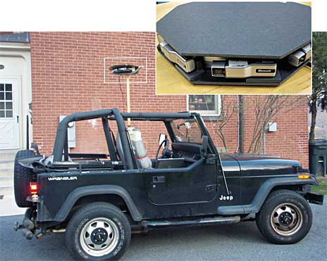
Using eight cheap webcams, a GPS receiver and open-source software, West Point graduate Roy D. Ragsdale built a rig that can do what Google’s Street-View cars do: take images of the world around it and stitch them together into panoramas. The difference? This version can be carried on your head and cost just $300 to make. The hacked-together software suite can even throw out files that can be viewed in Google Earth.

OSM now in 26 more languages

  • El WikiMapaMundi libre
  • La wiki-mappa Libera del Mondo
  • Die freie Wiki-Weltkarte

OpenStreetMap now recognises a total of 51 languages for the main website and is available over at TranslateWiki if you want to help with the effort of refining those or adding more!

Check out the clear progress for each language and also chart of strings added per day.

As avar says, “with a week more of Translatewiki we should have as much translation activity as we’ve gotten in all the time since the site was made translatable in May”.

Flickr adds OpenStreetMap machine tag goodness

When you tag photos in flickr with OSM metadata like ‘osm:way=30089216’ the squirrels will busily work to figure out what you’re talking about and link over to OSM. See this example and scroll down to look at the machine tags and stuff on the right. It figured out the building from the road it’s on and the name of the photo. Magic.

Also, check out the flick blog post on the subject.

DeCarta support OSM

Woo! Check it out.

San Jose, California – September 16, 2009 – deCarta, the leading supplier of software and services for the Location-Based Services (LBS) industry, today announced the launch of its beta program supporting OpenStreetMap (OSM) data.

The beta program makes the OSM content available for selected cities around the world. A product release that will support the complete coverage of OSM is scheduled for October 2009.