Author Archives: 80n

Hardware Upgrade Appeal: Thank you

Wow, what a week. We launched the Hardware Upgrade appeal last Thursday to raise £10,000. And just 2 days 15 hours and 20 minutes later in the small hours of Sunday morning we reached that target.

Cray X-MP/48 Supercomputer

This all happened so quickly we were astonished and totally humbled by the generosity and goodwill towards the project. It happened so quickly in fact that we felt that a lot of people wouldn’t even have had an opportunity to donate, so we decided to keep the appeal open a bit longer.

So after exactly a week we are formally closing the appeal having raised £16,222. The donate site will still stay up but we’ll change the wording so that it’s for general fund raising and not focused on any particular need.

We have some very big thank yous to make. Firstly, we are enormously grateful to Google. The guys from the Google Open Source Programs Office really appreciate what we are doing and donated £5,000. Awesome.

Second we have to thank CloudMade. Steve and Nick are always the first people to dig deep and support the project, whether it’s tile hosting for cycle maps, organizing mapping parties or sponsoring the State of the Map conference. Once more they didn’t hesitate and donated £2,000. Thank you CloudMade.

Third, Richard Weait deserves mention. Richard does a lot for OpenStreetMap. Running mapping parties in North America, talking at countless Linux User Group meetings, coordinating mass geodata imports and, um, designing curling icons. On top of all this he donated $1,000 out of his own pocket. Props.

And last, but definitely not least, we need to thank every single other person who made a donation. Collectively you raised all the rest – in true crowd sourced style. Your roll of honour is here. Each and every single donation is really appreciated. Thank you guys.

3U server

We’ve raised enough for a new database server. It will probably be a better spec than we had planned or hoped for, so it should see us good for some time.

And with the remaining funds? Well I think everyone agrees that the wiki server could use some better hardware so we’ll be able to take care of that. Beyond that, if the community has any ideas then we’d really like to hear suggestions for what else needs a bit of a boost. Please tell us which other core services you think would benefit from a bit of help.
68 GPS units donated to OSM

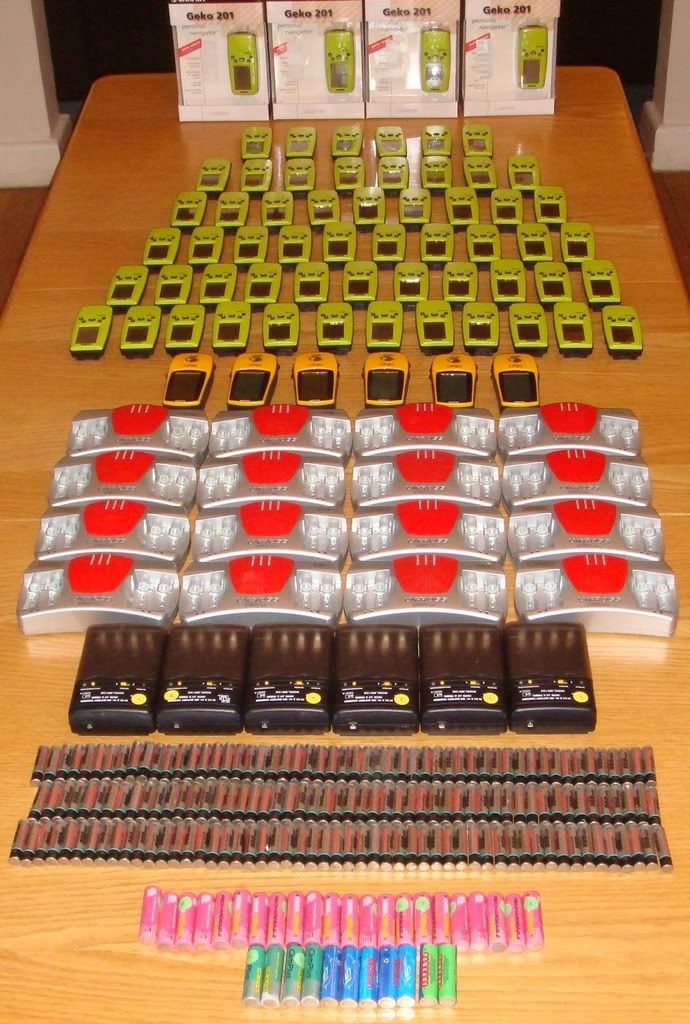
We are delighted to announce that OSM has received a donation of 68 GPS units. Thanks go to James Doughty of Diass who very kindly donated them.

Donated GPS Units

In addition to the 68 GPS units, which are mainly Garmin Geko 201s, James also provided an assortment of batteries, battery chargers and cables. There’s a full inventory of everything we received here (google spreadsheet).

So now we have to decide how to make the best use of them. Obvious uses are mapping parties and the GPStogo scheme, but if anyone has other good ideas for ways that we could use them then we’d really like to hear about it.

The state of Terminal 5

Heathrow terminal 5 opened today. With a capacity of 30 million passengers a year (representing an estimated 50,000 car journeys per day), and having been under construction for over five years, you would expect it to be clearly marked on all the leading on-line maps.

So lets have a look at the state of Terminal 5:

Google Maps

Google

Hmmm… no sign of Terminal 5. OK, the new junction from the M25 is shown and half of the spur road, but then it incorrectly becomes an ordinary road. And where T5 should be the old sewage farm access roads are still showing. Really, if you look at Google Maps there’s not much of a clue where T5 is likely to be.

Microsoft

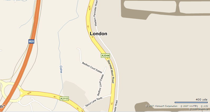
Microsoft

So what about maps.live.com? No sign of T5, no new motorway spur road. Nothing.

Multimap

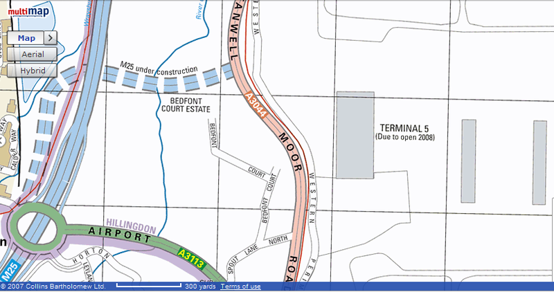
Multimap

Now we are getting somewhere. The T5 terminal building is shown and the satellite T5B building. But wait! So is T5C which hasn’t been built yet. Maybe they are getting a bit ahead of themselves.

Well, maybe not, the M25 access road is still shown as under construction (even though it’s been in use by local taxi drivers for over a year) and no it doesn’t connect to Stanwell Moor Road. Oh, and if you zoom out too far T5 disappears, the link road loses it’s motorway status and the old sewage farm access roads re-appear. Oh dear.

Streetmap

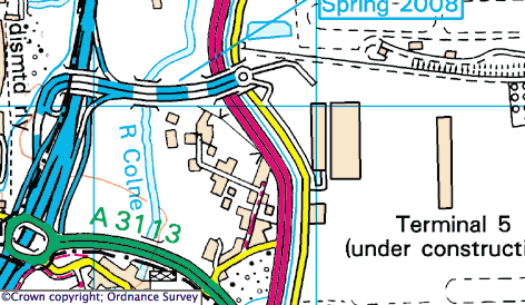
Streetmap

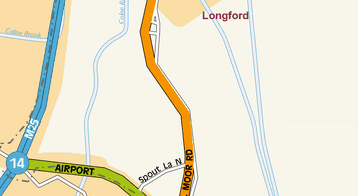
Streetmap looks promising. T5 and T5B are shown, but marked as under construction. T5C is not shown; extra marks for getting that right. The motorway spur road is shown correctly terminating at a roundabout, and the access roads into the terminal are show as stubs. Almost full marks so far. Zoom in a bit… oh dear, the motorway spur now terminates incorrectly at Stanwell Moor Road, all the local access roads are gone, and T5C suddenly appears. Arrgh.

Mapquest

Mapquest

Sigh.

BAA

British Airports Authority are the owners of Heathrow Airport. Surely their web-site will have a decent map.

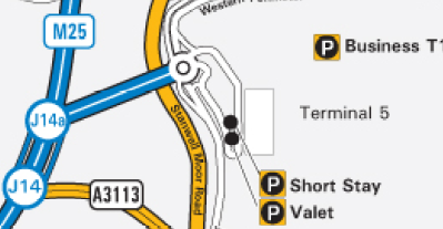
BAA

Umm… no. They show terminal 5 as being reached via junction 14A. Sorry guys, there is no junction 14A. And where’s Whittle Road, the access road from the Western Perimeter Road into the southern end of the terminal building? And don’t you remember constructing T5B? Well at least you’ve marked some car parks.

The AA

The AA

Just don’t expect the Automobile Association to help you find it.

OpenStreetMap

OpenStreetMap

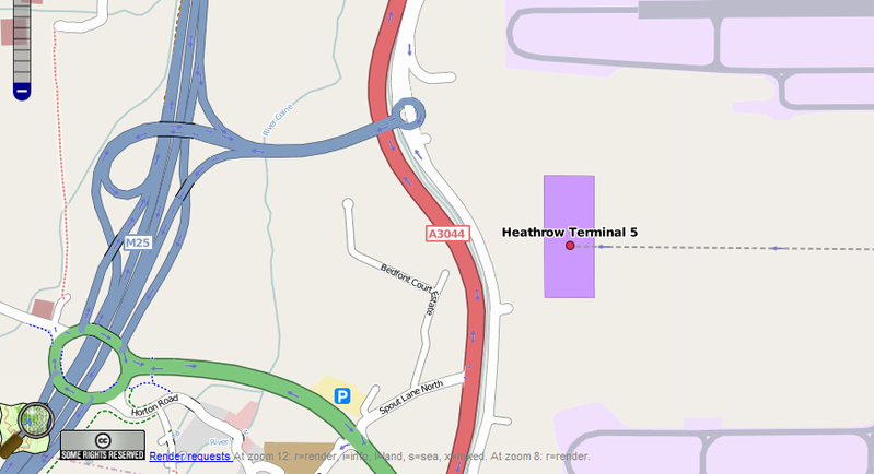
And finally, lets look at our own efforts in OpenStreetMap. The M25 spur road and the main terminal building are both shown. The local access roads are just stubs, but that’s understandable as there’s been no public access past these points until today. As a bonus the Piccadilly tube line is also shown. It’s not quite perfect though. The roundabout at the end of the spur road is marked as having motorway status, which it doesn’t, the T5B satellite building is not shown, and nor are any car parks.

Searching
Trying to locate terminal 5 using each map’s search facility produces equally disappointing results. I tried the search term “Heathrow Terminal 5” in each one:

  • Google gets the location spot on, describing it as Heathrow Airport, Heathrow Terminal 5 (S-Bound).
  • Microsoft finds the airport but locates the airside of terminal 3.
  • Multimap finds the airport but locates terminal 4. Oddly, searching just for Heathow locates terminal 5!
  • Streetmap says: The search returned no matches.
  • Mapquest provides a helpful pulldown list of UK airports, sadly it only lists 4 terminals at Heathrow.
  • The AA can help you find any terminal at Heathrow except terminal 5.
  • OpenStreetMap gets the location spot on, describing it as Heathrow Terminal 5.

Heathrow’s terminal 5 is a major high profile new development. On it’s own it is bigger than any other airport in Europe except Frankfurt. It will generate, from today, more car journeys than a decent sized town. Yet most of the on-line mapping sites don’t seem to be capable of having a decent map ready on the day that it opens.

It’s examples like this that demonstrate how well OpenStreetMap can produce accurate and timely maps. Further vindication of the effectiveness of the OpenStreetMap approach.

GPStogo is go!

When we started to hear stories about OSMers in far flung corners of the world begging and borrowing equipment in order to help OpenStreetMap, the OSM Foundation wondered what it could do to help.

Well, after a protracted gestation period we are pleased to announce the GPStogo scheme. Its quite simple. We collect small donations from our supporters in wealthy countries, use the money to buy GPS receivers, and loan them to enthusiastic but poorly equipped OSMers in developing countries.

There’s full details of the scheme on the brand new OSM Foundation web-site.

We already have some promises of donations and a (short) list of worthy recipients, so the pumps are primed.

Our initial goal is to purchase one GPS receiver a month and ship it out to whoever is next on our list of qualified loan applicants.

All we are asking is for OSMers to donate a fiver a month to support this scheme. You’ll get lots of kudos and have the satisfaction of seeing map data appearing in some of the more distant corners of the planet. Sign up here.

And if you are a GPS-less budding OSMer in a developing country then please get in touch, we need to know what you need to be able to go out mapping. Let us know here.