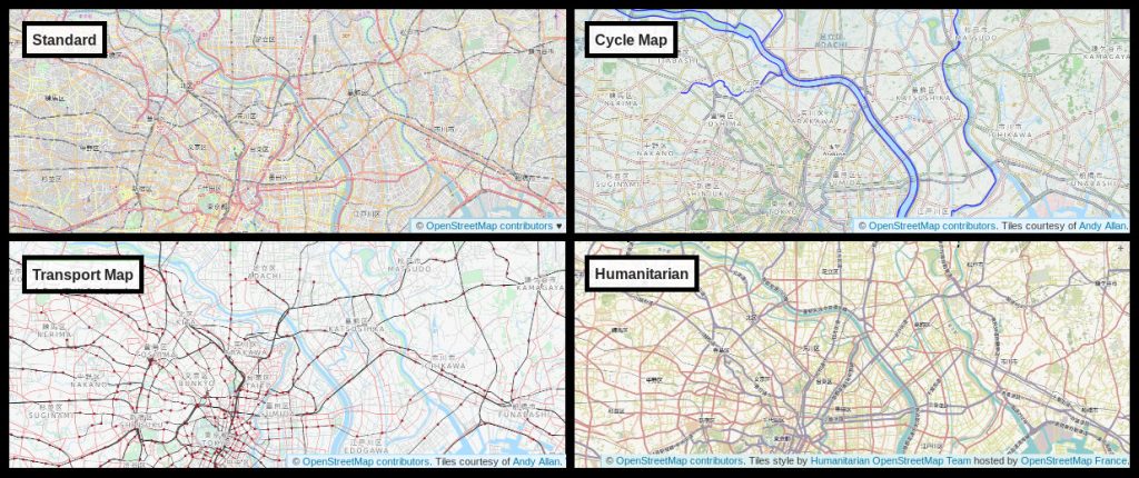
Top left: Standard layer (OpenStreetMap Carto). Top right and bottom left: Cycle Map and Transport Map layers – tiles courtesy of Andy Allan. Bottom right: Humanitarian layer – tiles style by Humanitarian OpenStreetMap Team hosted by OpenStreetMap France.
Layers on openstreetmap.org
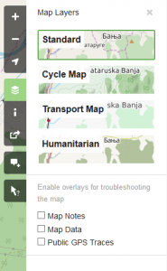
On openstreetmap.org you can switch between different “layers” offering different views of the same mapping data. Do this by clicking the layers icon (fourth button from top on right sidebar, highlighted on the image below).
 The layers we currently have are:
- “Standard” (OpenStreetMap Carto) is the default layer on osm.org
- “Cycle Map” (OpenCycleMap by Thunderforest),
- “Transport Map” (Transport by Thunderforest) and
- “Humanitarian“
These views are rendered in different ways (being turned from raw data into a map image), although all of these use Mapnik software. Because the layers are running on different server infrastructure with different set-ups, one layer may be more out-of-date compared to another (recently mapped roads not showing up).
Call for more featured tile layers
We are interested in new featured layers that highlight different aspects of OpenStreetMap. In particular it would be nice to have submissions for layers that:
- aren’t based on the Mapnik software stack,
- are topographic maps,
- are walking-focused maps, or
- are non-raster maps, along with help integrating them to the website
No one style needs to meet all the above points, but they’re some areas we currently lack.
Criteria for layers
Proposed new tile layers that will be featured on the OSM website should follow the guidelines set out in the new tile layers policy.
Contact
If you interested, please find the contact email in the layers policy page.
Do you want to translate this and other blogposts in your language..? Please send us an email to communication@osmfoundation.org with subject: Helping with translations in [your language]
The OpenStreetMap Foundation is a not-for-profit organisation, formed to support the OpenStreetMap Project. It is dedicated to encouraging the growth, development and distribution of free geospatial data for anyone to use and share. The OpenStreetMap Foundation owns and maintains the infrastructure of the OpenStreetMap project, is financially supported by membership fees and donations, and organises the annual, international State of the Map conference. It has no full-time employees and it is supporting the OpenStreetMap project through the work of our volunteer Working Groups. Please consider becoming a member of the Foundation.
OpenStreetMap was founded in 2004 and is a international project to create a free map of the world. To do so, we, thousands of volunteers, collect data about roads, railways, rivers, forests, buildings and a lot more worldwide. Our map data can be downloaded for free by everyone and used for any purpose – including commercial usage. It is possible to produce your own maps which highlight certain features, to calculate routes etc. OpenStreetMap is increasingly used when one needs maps which can be very quickly, or easily, updated.
The “layers policy page” does not have an email address, so…
I would love to see something like https://openstreetbrowser.org/ be available on osm.org. Having clickable Metadata (which we have so much more of than other map providers) would be very important to make OSM a viable choice for users that are used to interact with a map instead of just scrolling and zooming.
I am not the author nor related to the author of osb.org but I am sure he would appreciate a tighter integration of his work… however, I think the requirements mentioned on the site are very exclusive and only companies could afford stemming the traffic alone.
I feel, more bitmap tile layers are the wrong way, even with vector markers like openstreetbrowser.
We need vector-tiles on the OSM server and a homepage / app and client side rendering.
There are so many OpenXxxMap.org that could be replaced by a single rendering
with just “styles” to show the map with special topics.
If the Operations Working Group is the one to handle a next gen rendering,
I should join it.
This is not to request a specific type of new map – this is to request the option to enable toggling of relief shading on all maps, just as the cycle map has by default. It adds so much more liveliness to the map and will leave many newbies speechless when landing for the first time on our website.
Oh, I did not know, the additional layers are and can be “outside” the OSM infrastructure.
And you are looking for already running solutions. I would like to include OpenMapTiles:
https://openmaptiles.com/downloads/dataset/osm/#16.44/51.50303/-0.11966
(You have to load it twice to see the London Eye)
No zoom-level steps but smart zooming. Not much functions – yet, this clinetside concept is widely improvable.
Pingback: weeklyOSM 506 | weekly – semanario – hebdo – 週刊 – týdeník – Wochennotiz – 주간
Pingback: [Перевод] Новости из мира OpenStreetMap № 506 (24.03.2020-30.03.2020) | INFOS.BY
Pingback: Новости из мира OpenStreetMap № 506 (24.03.2020-30.03.2020) — IT-МИР. ПОМОЩЬ В IT-МИРЕ