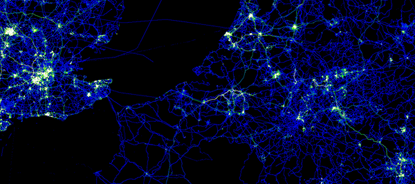
OpenStreetMap contributors have used track files from their GPSr devices for years while improving OSM data. They have shared those track files and the track points have been available to other mappers via editors and the web site. Now we are providing a way for you to get all of those points at once.
Announcing planet.osm.org/gps
This is the collected GPS point data from the first seven and a half years of OpenStreetMap. It is a very large collection of points and it is very raw data.
- the compressed file is 7GBytes in size
- uncompressed, the file is a 55GByte text file
- the data consists of coordinate pairs only, with no track file or meta data
- points were contributed by thousands of users
- points were contributed as thousands of distinct track files
- the data includes 2,770,233,904 points
Is this a big deal?
This might be the largest collection of Open Data GPS points published. Do you know of larger collections? Tell us in the comments.
Working with this file might not be your cup of tea
. Over time, I expect that tools will emerge from the community to make this data easier to manage. For now, it is raw and it is extensive.
All of this data has been previously available to OpenStreetMap contributors in other forms, via editors and the web site. This file provides a new way to get the same data and to get all of it at once.
Example data
If you do decide to work with the file, this is the format that you can expect.
-900000000,1771882380

-900000000,1293757490

-891154290,1237501070

-877697750,1653442410

-871875000,1589069750

-871875000,1237507350

-843750000,1350007780

-843750000,1153132660

-843750000,1040632590

-843750000,1012507800

-843750000,1012507340

-824414060,1082922390

-815625000,1575007660

-805627440,1579614290

-805517580,1579284700

-805517580,1578845240

-804473020,1373773550

-787500000,1237507380

-787500000,1181257510

-787500000,1096882780

-787499970,1096882780

-778591613,1666901550

-778591613,1666898345

-778591384,1666911621
What format is that?
These are comma separated, raw lat / lon coordinates in a simple text format. To get the coordinates divide each number by 10**7. The points are sorted by location, starting in the far southeast of the globe (90 S,180 E) and moving northwest.
Thanks
Thanks as always to the hundreds of thousands of OpenStreetMap contributors over the seven-plus years of the project so far. Thanks to the syadmins for moving this data to a place where we can all access it.
This version of the GPS data file is CC-By-SA and published by OpenStreetMap and Contributors. The image in this article is a visualization of some of this point data in Europe. The image is licensed similarly and was created by Dave Stubbs.

Its great to see this information released in a straightforward and comprehensive format. I’m looking forward to seeing how people put this to use!
Absolutely.
Felicidades, es una herramienta en la cual todos podes acceder y contribuir a esta gran comunidad.
I think this data set (2,770,233,904 points) should be used to benchmark Geographic solutions, like doing k-NN or extracting points that lie in a given zone.
I wonder how various offerings (PostGIS, ESRI, Oracle Spatial, …) will behave with that much data.
Is it possible to “chop” the collected GPS point data into extracts (for a certain area)?
Of course. Like with OSM planet extracts, I expect someone in the near future to 1) make regional extracts; 2) make a tile layer for editors.
Pingback: OpenStreetMap ha rilasciato i dati “grezzi” con la mappatura dei GPS | RampaCrew
maybe it is worth to include the elevation data. Alhough the VDOP is usually worse than HDOP, it might be possible to average with sufficient points and improve the SRTM DEM.
And more importantly, vector data ? This file is a great useful start, but without knowing how points are connected, it’ll be hard to make sense of the data.
Are we thinking OpenTrafficMap.org ? Anyone? Congestion, average speed, bottlenecks etc…
but for now, pretty visualisations.
I second this thought!
Pingback: OpenStreetMap ha rilasciato i dati “grezzi” con la mappatura dei GPS | Indipedia – Indipendenti nella rete
Actually I’d prefer to have, in the near future, possibility to reach full track data (with DOP, markings etc) available through API and planet. It is tough to process, I know, but still, without HDOP it’s often completely useless (I mean, what do you want to use it for if it’s possibly 100 meters off the mark?)
For raw data, that is raw data !
I hope this is a first step, because it’s hardly usefull in this form (beside for statistics saying we have 2.7T points) gpx uploaded traks by users contains more informations than just points :
– order of points
– date of the recording
– elevation (sometimes)
– HDOP (sometimes)
which might be much more interesting
Yeah, date of recording is very important because some things change over time. A big freeway “commons” area has been rebuilt in my area in the time since OpenStreetMap started, but old GPS traces from the original layout still exist and clutter things up. Being able to filter out older traces would be helpful.
We (OSM sysadmins) are working on a much larger GPX dump retaining as much data as possible.
Code in progress here: https://github.com/iandees/planet-gpx-dump/
Pingback: Mappe 'Open': Wikipedia e Foursquare insieme ad Apple nell'abbandono di Google Maps
Thanks for sharing this data!
I’ve produced a heatmap visualisation using a random sample from this data set, using geohashes to bin the points into a grid.
Good work, I am planning to do something similar and compare the distribution of OSM updates and geo-located microblog postings to Twitter. I expect to identify residential places, but I wonder what else will out… Cheers, Andy
Pingback: Mappe ‘Open’: Wikipedia e Foursquare insieme ad Apple nell’abbandono di Google … – HDblog (Blog) | Foursquare Italia
Pingback: Open Street Map GPS users mapped — Mask-Africa Renewable Energy
Pingback: 55gb file with 7.5 years of openstreetmap bulk gps data now available | ChrisVR
Pingback: Open Street Map GPS users mapped « Another Word For It