Monthly Archives: October 2011

Weekly OSM Summary #28

October 5th, 2011 – October 17th, 2011

A summary of all the things happening in the OpenStreetMap (OSM) world.

  • Nearly 100% of Denmark’s streets have been mapped by OSM. Currently 97.2% have been mapped. You can use a map or a form to search for missing ways.
  • In Wales the road names show a completeness of more than 95%. Thx at Ito for their analysis. You will find further results at their webpage.
  • The “Big Baseball Project 2011” tries to map all baseball fields around the world until October 27th, 2011. You will find the user ranking, a baseball-map and a beginner’s guide in our OSM wiki.
  • France has now its own local OSM chapter.
  • Martijn van Exel, Randy Hale, Jim McAndrew and Michal Migurski have been elected and Richard Welty has been reelected for the US local chapter. Congrats to them!
  • Because of an Edit-War about the name of the city “Jerusalem” the name-tag will not be used any longer in this specific case. The question is should the name be written in Hebrew or in Arabic?
  • The OSM Inspector “Routing view” is now available with a worldwide coverage. It shows errors in the OSM street network such as unconnected or duplicated ways. Read the full blog post and further news here.
  • Researchers from the National University of Ireland, Maynooth conducted a „Comparison of the accuracy of OpenStreetMap for Ireland with Google Maps and Bing Maps“. Read their full paper here.
  • The project OpenArialMap added some new images.
  • Get your own Hiking Map in ten steps with Maperitive.
  • Richard Fairhurst created a Ruby ODF Renderer for OSM data. Read his full announcement here.
  • Peter Körner created some new extracts of the OSM full history database dump. His announcement at the OSM developer mailing list can be found here.
  • Kai Krüger built some packages, to install and run your own OSM map tile server on an Ubuntu operating system. Find more information on the OSM wikipage.
  • The Android app for the wheelmap.org project is now available at the Android market.
  • MapQuest launches Mobile Flash Maps API”. You can use it within Flash Builder 4.5 native mobile applications.

Did we miss something? You can contact us via weekly.osm@googlemail.com

Authors: Pascal & Dennis – (thx @ “Wochennotiz”)

Big Baseball Project 2011

To coincide with baseball playoffs and the World Series we’re running
a special mapping project:

The big baseball project!

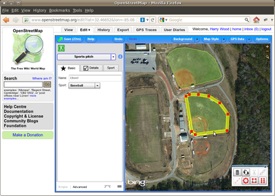
Help adding baseball diamonds to OpenStreetMap. This is a really easy
type of map editing which anyone can get involved in, so give it a go,
and tell a friend! If you live in the U.S. (or some other baseball
fanatical part of the world) you can start by looking for baseball
diamonds near where you live, but these things are easy to spot in the
aerial imagery. This means everyone can help, from wherever you are in
the world. You can even contribute to the free world map while you’re
watching the MLB playoffs on TV!

We’re tracking baseball edits to bring you a rolling edits display and user rankings, but you’ve only got until
October 27th to become an OpenStreetMap baseball champion!

You’ll find more guidance on the wiki, plus a short press release.

Weekly OSM Summary #27

September 19th, 2011 – October 4th, 2011

A summary of all the things happening in the OpenStreetMap (OSM) world.

  • “LearnOSM.org provides a simple-to-use, step by step approach to learning how to make maps with OpenStreetMap”. Visit the new website here.
  • The new OSM servers zark, soup, fiddlestick and eustace are online! Thanks to bitfolk.com and Nokia UK.
  • “The Licensing Working Group has obtained explicit special permission to incorporate geographic datasets from data.gov.au in the OpenStreetMap project database published under any free and open license …“ Read the full announcement here.
  • A new tool that helps to coordinate upcoming Humanitarian OpenStreetMap Team (HOT) projects is online. Read the full blog post about the “OpenStreetMap Tasking Manager” here. And the next HOT meeting will be on October 5th at 11pm.
  • New international boundaries from the US Department of State are available. Read more here.
  • Google released a new commercial spot for their Chrome browser in which they featured the Wheelmap.org project. Watch the German video on YouTube. Also, they are searching beta-testers for their Android-WheelpMap app. If you are interested, drop a mail to: android@wheelmap.org
  • A nice blog post about mapping in Afghanistan.
  • If you want to see “live” editing in the OpenStreetMap World, you can check “OSM Live“, “khtml.org” or “GeoXP“.
  • A new blog post by Martijn van Exel: “Taking the Temperature of local OpenStreetMap Communities”.
  • The Geofabrik also supports a free shapefile download of OSM land use areas now. You can read the full blog post here.
  • OSMT is a new tool for splitting or merging OSM data.
  • A new HTML5 demo shows the rendering of OSM data within the web browser. Try it out here.
  • Michal Migurski provided a new website where you can download OSM data “for major world cities and their surrounding areas“. You can find it here.
  • The 2.0 version of Mapnik is finally out! Mapnik is the software we use for rendering the main map layer for OSM.
  • Michiel Faber and Guttorm Flatabø created a script that merges several GPS tracks into a “line of best fit” / average track.

Did we miss something? You can contact us via weekly.osm@googlemail.com

Authors: Pascal & Dennis – (thx @ “Wochennotiz”)