Interesting INSPIRE centric article about how all the National Mapping Agencies will consolidate their holdings through EU Directive(s). I’m really still puzzling over why this is important. I think creating our own data is going to be better than political engagement on this, the NMAs are very well entrenched and we already hold the moral high ground.
XTech
I’ll be speaking about OSM at XTech 2006 on 16-19 May in Amsterdam
LUGRadio Live
I’m speaking at LUGRadio Live 2006 on Sat 22nd and Sun 23rd July 2006 in Wolverhampton. This is at WV1 1LY and someone should add that to freethepostcode 🙂
Isle of Wight workshop
http://wiki.openstreetmap.org/index.php/OSM_Workshop

What:
Isle of Wight mapping workshop and general get together for
OpenStreetMap.org fans where we plan to map the entire Isle using GPS on
cars, cycling and by foot. This is our first official meetup and will
result in a released map of the Isle of Wight.

When:
Friday 5th to Sunday 7th May. Cottage probably booked 30th April -> 7th
May and all welcome at any point.

Where:
Isle of Wight, off the south English coast:
http://www.openstreetmap.org/index.html?lat=50.688627413475814&lon=-1.376037&zoom=11

Who:
You? I need 50 GBP non-refundable deposit per person for cottage by
the 27th Feb ideally. Once booked we can add people an upgrade the
cottage size. You can attend for free, of course, but without a cottage
we have no base for things like computers so please stay with us :-)

Final cost for accomodation likely to be between 60-100 GBP
depending on sponsorship and numbers. Paypal steve at asklater.com with 4%
added for paypal charges or email for bank or cheque details.
People welcome to crash on the floor if space available.

Sponsorship:
I'm going to people asking for sponsorship of car rental, accomodation,
food, GPS units etc. If you can provide sponsorship or know someone who
can then get in touch.

Details, details:
Please update the wiki with travel info, offer lifts, equipment you'll
be bringing, etc.
OSM decentralisation
OSM has traditionaly run nearly everything off on one box. The wiki, mailing lists, source repository… everything. These little bits have now been moved to a VM machine donated by bytemark. Thus the wiki is now at wiki.openstreetmap.org, subversion source is at svn.openstreetmap.org, mailing lists are at lists.openstreetmap.org and the bug database trac is at trac.openstreetmap.org.
All this takes load off of the main machine and allows for easy migration in the future.
Animations
I’ve put together three map animations of progress in OpenStreetMap: London, Birmingham and the UK. Your browser might crop the timestamp at the top so it’s best to download and play it directly.
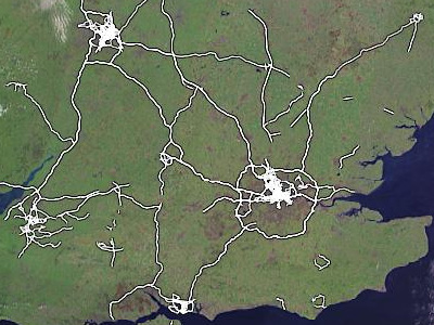
UK Motorway Carriageways Complete!
Etienne Cherdlu writes:
I’m pleased to announce that the main carriageways of all mainland UK motorways have been completed. Over 3,000 km of roadway.
This does not include motorways in Northern Ireland nor does it include motorway sections of A roads, so there is still plenty of work to do.
Indeed, the user contributions are now outstripping the current editing software! In the works is functionality to classify the motorways so they can be rendered more effectively in our map drawing software and used effectively in any future routing algorithms.
Still, this is an excellent result, well done to the UK Motorways team, who could still use your help in adding/refining junctions and checking for consistency.
In other news, OpenStreetMap gained it’s 1000th registered user just before the new year.
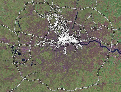
London GPS Animation
OpenStreetMap has contributors all over the world, and our biggest UK contributor is London-based courier firm eCourier. They kindly provide us with GPS data collected by their couriers, and when you edit a part of London it’s almost certainly thanks to them that the roads are so clear and easy to trace.
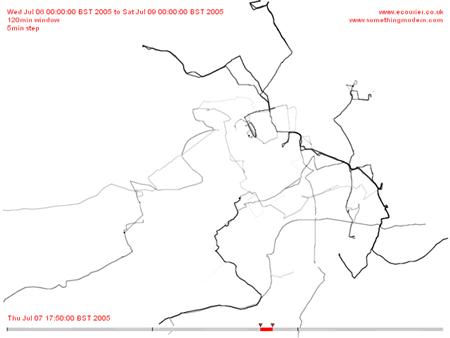
We made a short animation to illustrate a sample of their data which they are hosting here, and you can check out their site and read more about our collaboration on their news page.
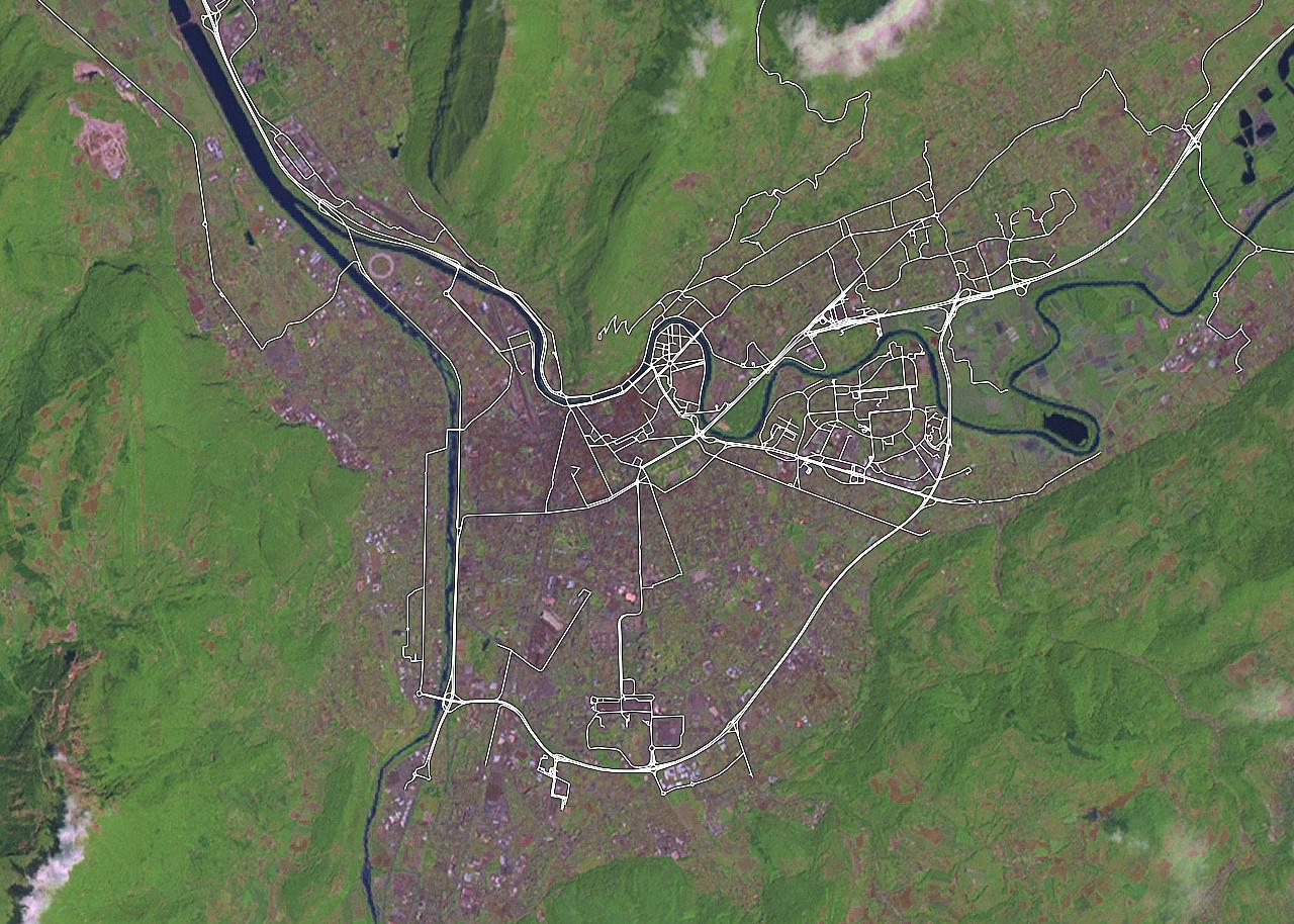
Open Grenoble Map
I remembered my favourite town so far in OpenStreetMap, it’s Grenoble in France. Again, the product of dedicated hands unknown, this time it’s worth clicking in for a closer look…
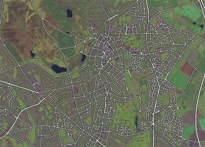
Open Birmingham Map, and more
Over the last few months, whilst our developer eyes were on raw data for London, REST APIs, AJAX, new applets and stuff, a few enterprising souls have actually been mapping their home towns in the West Midlands and stress-testing the OpenStreetMap software with impressive and surprising dedication.
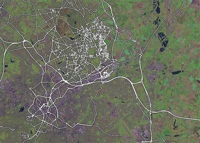
Apart from that, they (and others) have also been filling in Britain’s motorways (both carriages!) including the M25 and all its major junctions.
This post serves as a quick thanks to these folks (especially Alex, Andy and Simon – if I missed you, let me know) who’ve taken the time and effort to do all this work, and a promise from me and the other developers that extra tools (such as street names – a high priority) are on their way soon, along with a few more sensible ways to get your data back out again (we’re looking at various vector formats) and a few things to make your editing lives easier.
Keep it up folks, and do let us know if there are other areas being mapped with such care and attention. I know that Lars keeps a gazetteer on his wiki page, and I’m also aware of Portsmouth and Bristol being filled out nicely, so I’ll try and find some more inspriational areas soon.